


Global Warming and Regional Climate
Researchers around the world have been conducting studies to diagnose and predict climate change in terms of global warming due to anthropogenic green house gas emissions and interannual to decadal natural variability. In this course we also conduct global warming and climate forecast research from several perspectives including climate dynamics, atmosphere-ocean interaction, matter circulation, and snowy and icy regions.
Here I will introduce regional climate forecasting based on numerical simulations that utilize climate models. Climate models utilize computers to solve a system of equations formulated based on physical laws. They are a method of calculating temporal changes in climatic elements such as temperature and wind, and they are commonly utilized in weather forecasting.
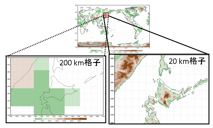
When forecasting the climate of a limited region such as Hokkaido, the horizontal resolution of numerical models calculating global climate is coarse, making it difficult to sufficiently portray regional climate characteristics such as effects resulting from fine topography (the left side of Figure 1, ca. 200 km mesh, often used in global climate model: right side of Figure 1, 20 km grid size for Hokkaido’s topography). When forecasting Hokkaido’s regional climate, we use the broad meteorological data for the Hokkaido region obtained from the global model (air temperature, wind speed, atmospheric pressure, etc.) and the detailed topographical data from the right side of figure as conditions. Then using a higher resolution regional climate model, the climate of the target area is recalculated (this method is called dynamic downscaling). (Note 1)。
|
Figure 1 |
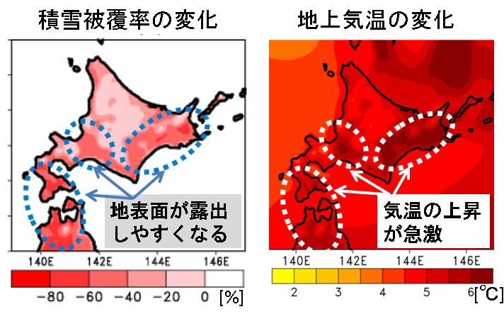
Based on the assumption that global warming will continue (Note 2), Figure 2 shows the forecasted results of winter in Hokkaido in the 2nd half of the 21st century based on calculations using the methods introduced above. The surface temperature rises for a fairly wide region, including Hokkaido, but the model also shows a rapid increase for low altitude regions within Hokkaido, such as plain regions during winter. This corresponds well to the change in snow coverage shown in the left portion of Figure 2. Compared to the mountains, in the relatively warm low-lying regions a decrease in snowfall would mean a delay in the first snowfall and cause an earlier snowmelt. As a result, it is thought that the period of snow coverage becomes shorter as the altitude drops. Because exposed land surface absorbs a higher proportion of the sun’s rays than snow (reflects fewer sun’s rays), the shorter the period of snow coverage, the greater the increase in the absorption of energy from sunlight. As a result, the increase in temperature for plain regions increases further. In addition, it is thought that the strong temperature increase of the Sea of Okhotsk is related to changes in sea ice.
However, because changes in snowfall and sea ice are connected to complex processes, the values given in Figure 2 still contain several errors. Looking forward, there will be a demand for investigations into how to increase prediction accuracy, and research on the interaction between atmosphere and land/snow.
|
Figure 2 |
|
Results related to the content on this page can be found here:
Matsumura, S., and T. Sato, 2011: Snow/Ice and Cloud Responses to Future Climate Change around Hokkaido. SOLA, 7, 205-208, doi:10.2151/sola.2011-052.
Note 1: Our research utilizes the WRF regional climate model (http://www.wrf-model.org/index.php) developed in the United States. For global climate forecasts we utilized a Japanese global climate model(MIROC) developed by the University of Tokyo Atmosphere and Ocean Research Institute, Division of Climate System Research, the National Institute for Environmental Studies, and the Frontier Research Center for Global Change.
Note 2: In line with future social change and economic development, the Special Report on Emission Scenarios (SRES) produced by the Intergovernmental Panel on Climate Change (IPCC) provides a future scenario of greenhouse gas emissions. In our research we conduct prediction experiments based on the A1B emissions scenario in this report. A1B assumes a scenario for society whereby there is continued economic development and a narrowing in the disparity between international regions. Using data from 1980-1999 as a standard, the global model used in this scenario forecasts a further 1.7-4.4℃ rise in the average annual land surface temperature (global mean value) for 2090-2099. In the MIROC model (MIROC-medres) used here, the temperature difference for the same period is about 3.3℃.